01

Dropla vision

Next-Generation Multi-Sensor Cartography
An advanced software platform that integrates optical, multispectral, thermal, magnetometric and LiDar sensing with AI-driven analytics — delivering precise, automated detection of explosive threats and intelligent mission planning for EOD and Demining operations.
02

Introduction to Dropla Vision

A Revolutionary Platform for EOD Missions
Built on comprehensive ground truth datasets, this solution offers unmatched accuracy in identifying landmines, UXO, and other explosive hazards. By fusing data from multiple sensor types and applying AI-powered interpretation, the system streamlines EOD workflows — from detection to post-mission reporting.
03

How It Works

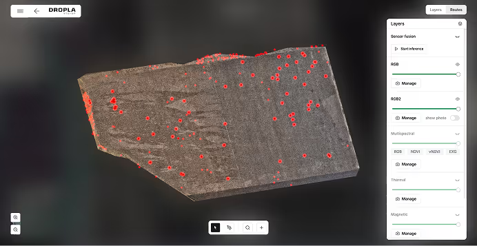
Four Sensors, One Intelligence Layer
‍The core of the platform lies in multi-sensor fusion: Optical (RGB), Thermal, Multispectral, Magnetometric


These inputs are combined to generate a high-resolution understanding of the terrain, both surface and subsurface. AI models then analyze the data to detect anomalies, classify threat types, and prioritize items for inspection or clearance.
Detects concealed threats across multiple data layers
Differentiates mines, UXO, clutter, and natural anomalies
Continuously improves accuracy with mission-based learning
04

Mission Planning

Smarter Mission Planning for Faster Land Release

The integrated Mission Planner enables fully autonomous route generation for unmanned ground vehicles (UGVs) of any type — from heavy demining machines to lightweight robotic platforms. By setting key operational parameters, operators can deploy missions without the need for manual navigation or path planning.

The system is highly adaptable to various terrain conditions and vehicle configurations. Real-time sensor fusion and AI-driven analysis are used to dynamically select safe paths, prioritize threat zones, and orchestrate effective area clearance with minimal human intervention.
Interested in your vehicle integration?
05

Key Software Features

The Dropla Vision interface provides a suite of professional tools that enhance efficiency and control:
Most familiar UXO
Detection
Sensors approve
Reports, Sensor Fusing,
Mission Planning ect.
Layered sensor data visualization
Precision marking tools
Auto-generated land release reports
Classifications UXO
Mission Planning
Role Manager System

Transform Your Demining Operations
with Dropla Vision

Loading page...